Click here to see photos of our recent walks.
Disley 13 April 2025
“A” Walk – 11.5 miles – Leader Yvonne Mason
We leave Disley passing the church, and then get onto the Gritstone Trail, which skirts The Lyme Hall Park Estate, eventually reaching the Bow Stones. These are ancient ornate boundary stones. We then go along the ridge top of Park Moor, the highest point of the walk at 410 metres, with fabulous views all around, as has ,most of the walk.
We then drop down towards Pott Shrigley, which used to be a heavily mined area, where you can still see evidence of this today. After reaching Dale Top, we head towards the pretty wooded valley of West Parkgate, and into the actual Lyme Hall estate. After a while, the magnificent Hall comes into view. Here we can use the toilets in the restored Mill Buildings and then go past the Hall Entrance and Stable Block, before walking up to the focal point The Cage. This used to be the Hunting Lodge, where the ladies could watch the hunt, and in the evenings used as a banqueting hall.
It’s just a short descent then back into Disley.
“B” Walk – 9 miles – Moderate – Leader Esther Williams
From the Rams Head Pub, we follow the Gritstone Trail up Red Lane out of Disley and then along Green Lane before climbing uphill to Lantern Wood. As we emerge from the wood the views are far-reaching towards Manchester and the Cheshire Plain. We continue along Higher Moor towards Sponds Hill then descend from Dale Top. Continuing through the West Parkgate of Lyme Park we follow the deep gorge of Cluse Hey, through Knightslow Wood and into the grounds of Lyme Park House where there are toilets. We then pick up the North Cheshire Way which leads up to Cage Hill and back down Red Lane to The Rams Head.
This is a moderate but hilly walk along good footpaths, lanes and greenways with a few stiles including some ladder stiles.
“C” Walk – 6 miles – Leader Bryan Clydesdale
This is a shorter version of the 2nd January 2022 C Walk led by Beryl Warrington and has NO STILES.
We start the walk at the Rams Head pub.
We have a gradual climb to walk out of Disley along Red Lane and cross the Bollinhurst Brook at Parkgate. then we continue on through Ryles Wood heading for the Macclesfield Canal.
Here we will follow the canal for a short stretch until we reach the Marina. Then we will leave the canal and now we are heading back towards Lyme Park. We have a long slow gradual climb up to Windgather with extensive views. We then arrive at Pemberley, the seat of Mr Darcy, in the 1995 BBC adaptation of Jane Austen’s novel Pride and Prejudice, This included the well-known scene when Mr Darcy emerges from the lake.
We will walk through the car park and here we can stop for an ice cream. Leaving the car park we are following the Gritstone Trail to the East Lodge where we leave Lyme Park.
Bollington
“A” Walk – 11.5 miles – Moderate – Leader Phil Mellor
This walk combines 4 of my previous walks in this area which covers the area South East of Bollington.
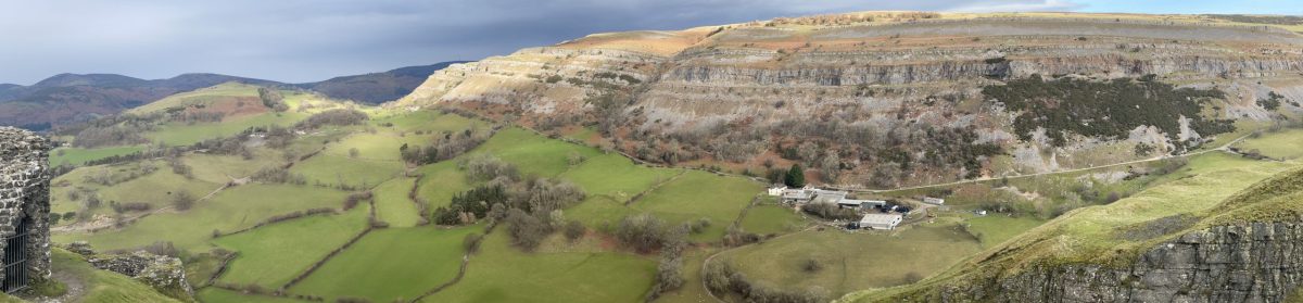
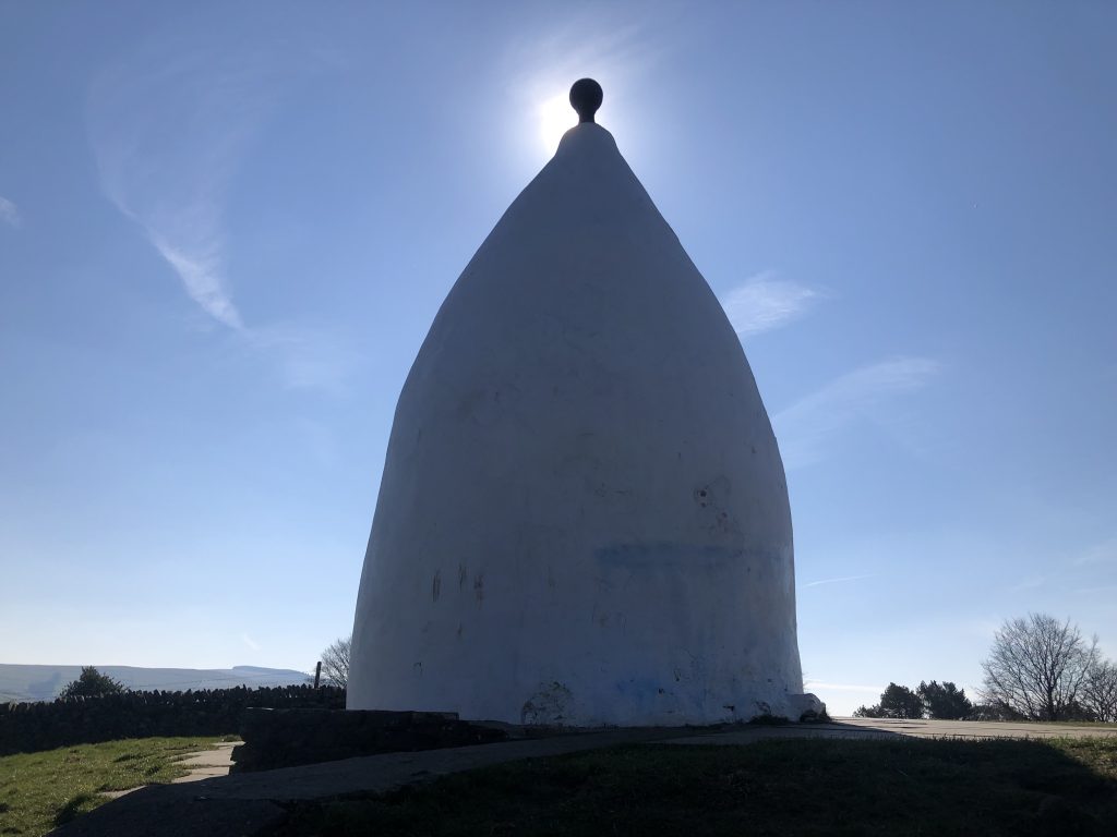
We start with a quick walk from the bus stop to the toilets on the town park before returning to join the canal for a short distance. Walking away from the canal towards Kerridge we pass cottages which must have one of the best views over Cheshire in this area. Now we have to gain height to the top of the ridge – we have 3 choices tough, moderate & easy, I will take the moderate route as the tough one has many steps. Now we have reached the top we have the option to visit White Nancy which is a feature overlooking the town of Bollington. After White Nancy we walk to the top of the ridge at 313M before dropping down to cross the Rainow road. Walking over fields we gain height again to drop down into the Rainow valley and by using the lane we make our way to Lamaload Reservoir. Using the top path we get good views along the reservoir before we join Hooleyhey & Ewrin Lanes [at Nab End we see the memorial stone to a strange event]. Now we start our journey back over more hills and lanes towards Rainow and then using Oakenbank Lane we cross over estate grounds to drop down into Bollington town and our coach which should be parked at the Bus stop as the local buses do not run on a Sunday.
“B” Walk – 8 miles with some some steep ascents and descents– Leader Mike Martin
We join the Middlewood Way for a short distance to the site of Bollington station.
From here we take to the Macclesfield Canal and follow this for about half a mile passing the Adelphi Mill.
Then it’s via a path to Kerridge where we begin the ascent to White Nancy. First on a minor road then onto gradually steepening paths as we join the Gritstone Trail for rough steps up to the top.
This is where we will take a breather to admire the views and have a coffee break.
Refreshed we now continue on the Gritstone Trail along the top of Kerridge Hill with the village of Rainow below us to the left and on the other side views towards Macclesfield.
After a while we leave the Gritstone Trail and head steeply down on paths avoiding Rainow before ascending to arrive at Tower Hill where there is a folly. We cross the main road here and head uphill on a path which starts alongside the road to Lamaload reservoir which we later join as far as Snipe House Farm. From there we head downhill passing Thornsett Farm and meet the main road again at Rainow.
We pass through this pleasant village before joining a paved way which takes us back towards Bollington passing a quite impressive waterfall near Waulkmill Farm. From here we follow a minor road past a derelict mill until we join the main road through Bollington where refreshments will be available.
“C” Walk – 6 miles – Leader Barry Comerford
From the car park we join the Middlewood Way at a viaduct of the disused railway re-purposed for walkers and cyclists. Heading North for 1 km then turning East to ascend gentle slopes up to Long lane with panoramic views from there. Gradually descending the lane into the town we head for the Waulkmill waterfalls, then skirting the base of White Nancy Hill through Kerridge and onto the Macclesfield canal towpath ending at the Clarence Mill.
Buxton 16 March 2025
“A” Walk – 11 miles (Moderate)– Leader Nick James
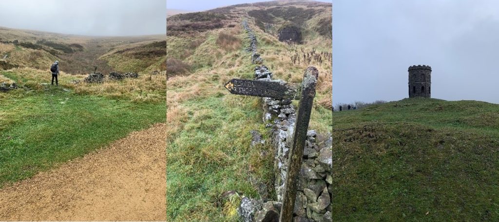
We will start the walk in the Serpentine Gardens and then climb up through some residential roads onto the old Roman Road out of Buxton. We then follow a winding path through farmland and woods towards the Errwood Reservoir. Weather permitting, we will have some great views across the Goyt Valley. We will then pick up the disused railway line of the Cromford & High Peak Railway recently resurfaced with funds from the National Lottery and ending at a blocked-up tunnel which would have emerged at Tunnel Farm on the outskirts of Buxton. At this point we will take Bishops Lane and pass through a secluded hamlet complete with Manor house, duck pond and farm. On the outskirts of Buxton we will climb once again through Grin Low Wood towards Solmon’s Temple, a Grade 2 listed building constructed in 1896. During the Victorian era, the tower was a popular destination for visitors to walk up to after taking the waters at the natural spa baths. Finally, we descend back into the town centre for our pick-up point next to the Pavilion Gardens.
“B” Walk – 9 miles – Leader Esther Williams
This is an undulating walk along roads, paved lanes, paths and grass tracks. Some areas may become muddy in wet weather and there is a short section of rough stones leading across a drainage ditch.
The walk begins near The Pavilion Gardens on Burlington Road where there are toilets. From here we follow the Dane Valley Way fairly steeply uphill to Buxton Country Park passing Poole’s Cavern, a 2-million-year-old natural limestone cave, and Grinlow Tower (Solomon’s Temple), a Victorian folly. The undulations in the ground are the remains of lime burning that once took place in the area.
Crossing Grinlow Road we continue south passing Stanley Moor and its reservoir, Turncliff Common and Anthony Hill towards Thirkelow Rocks. We begin our return north passing an area called The Frith which was used as an artillery range and test site for trench mortars during the 1st World War. We then pass disused limestone quarries before making a short climb back up to Grinlow and a return into Buxton where there are numerous pubs and cafes.
“C” Walk – 5.6 miles (Moderate with some long gradual rises)- Leader Tony Whiffen
We start the walk from Burlington Road where there are toilets in the Pavilion Gardens; we head out of the town towards open ground where there is some high ground to negotiate before dropping down and crossing Grin Low Road. We immediately take a footpath rising to high ground near Countess Cliff and head towards a farm at which point we will have our first stop and weather permitting will have magnificent views across the Derbyshire Countryside. After our stop we continue on a gravelled path towards Stanley Moor Reservoir (dis) and then to Ladmanlow. Here we pick up the Dane Valley Way into Buxton Country Park were we will have our lunch stop at one of the grass and rock formations. From here we head towards Grin low Tower (Solomon’s Temple) on route we will have a toilet stop at the caravan park before continuing towards the tower. If you have not been up the tower before it is well worth a visit, as on a good day the views are amazing. After leaving the tower we walk across the undulated ground formed by waste from the many lime kilns that were used in the area and head towards woodland that will eventually take us down from the high ground and back into the town of Buxton, where there are many pubs an café’s.
There are only a couple of styles and a few gates on this walk, and we will have time to take the high ground at a slow and leisurely pace. Enjoy
“D” Walk – approximately 3 miles – Leader Bill Pearson
After the successful D walk that we had in Ruthin on 2/3/25 we are able to offer another shorter D walk, for people who feel unable to do the above walks.
The D Walk leaves the coach on Burlington Road. There will be an opportunity to use the free public toilets in Pavilion Gardens Car Park (but if you can wait there are some nicer ones a mile later). We will walk along the River Wye, through Serpentine Gardens. These gardens were designed by Joseph Paxton, for the 6th Duke of Devonshire, in the 1830s. Sir Joseph Paxton was previously the gardener at Chatsworth House, and later designed the Crystal Palace for the Great Exhibition in London’s Hyde Park in 1851.
We will then proceed to Poole’s Cavern and Buxton Country Park, where we will have an early first break. Here there is a café, and clean toilets. There is an outside picnic area where you can consume your own food and drink, but only purchased food and drinks are allowed inside the café. We will then return to Buxton (using different routes where possible). We will visit the Pavilion Gardens, where there are boating lakes, a miniature railway, an art gallery, and ice cream parlour, a gift shop and café and a Botanical Conservatory as well as more toilets. We can also explore Buxton’s main shopping area (with lots of places selling tea and coffee), and past St Ann’s Well to the Pavilion Gardens. Edward Milner designed and laid out these delightful gardens for the 7th Duke of Devonshire, in 1871. He also designed the glass and cast-iron Buxton Pavilion, which echoed Crystal Palace. You can also the Opera House, which opened in 1903, and was designed by Frank Matcham – the famous theatre architect.Ruthin 2 March 2026
“A” Walk – 11 miles (Moderate/Tough) – Leader Phil Mellor
We start with a quick walk through the town to see the historic points of interest which are easily missed at the end of the day when the pub is the main destination. Following the river Clwyd we make our way to Rhos then start making uphill progress across fields and lanes before we start our main gain in height to the sumit of Moel Famau and Victoria Tower. At 550 Metres high we should get good views before we drop down to Bwich Penbarra at 356 metres where refreshments are available. Using the road and paths we make our way to Llanbedr-Dyffryn-Clwyd and our afternoon break at the church ruins, then after crossing fields we return to the town.
If we have poor weather conditions or if we feel that going to the top is an issue we can take the slightly lower walk along the base of Moel Famau using the Bridle Way which still gives us excellent views across the Ruthin valley.
“B” Walk – 8 miles – Leader Mike John Moreton
This walk is hilly but steady climbs not steep and one steep descent. We set off through the town with many attractions including a castle and a gaol. From there we ascend lanes and fields passing a caravan site then dropping down to a village called Bontuchel.then along the river through a wood to a bridge across the river and back across fields. It will be muddy and there is a handy water trough near the end where we can clean our boots to enable going into the pub. Advise bringing a brush or cloth.
“C” Walk – 6 miles – Leader Bryan Clydesdale
We start the walk at the Ruthin Craft Centre. We walk out of Ruthin along School Lane towards the Sports Ground. Crossing the main road we twalk alongside the River Clwyd then across fields to Plas-y-Ward. Leaving Plas-y-Ward we have some road walking into Rhewl.
Leaving Rhewl we head back to Ruthin walking beside the Afon Clwedog river along Lady Bagot’s Drive. Lady Bagot’s Drive is a nature trail ithat was originally a carriageway built by Lord Bagot for his wife. The drive was a favorite of Lady Bagot’s and is now a popular walking and cycling route.
Leaving Lady Bagots Drive we cross the Afon Clwedog on a small footbridge and then we have a short climb up to the road.
We continue crossing fields with some wet patches and arrive at the outskirts of Ruthin. Crossing the main road again we walk across the rugby fields around the Castle into Ruthin.
We now have a short climb to the town centre where we find the impressive Wetherspoons Pub and the town clock.
You can stop off here or continue on to the coach and the cafe at the Craft Centre.
D” Walk – 3 miles – Leader Bill Pearson
This will be an easy walk for people who are unable to do the above walks. As we have effectively have all day to do 3 miles the pace shall be be easy to manage, and we will have regular stops and breaks. WE usede a low level walk to Ruthin Gaol a “House of Correction”. We then walked throug the town to Ruthin Castle, where se stopped for coffee.
We will walked past Nantclwyd y Dre, a historic house and gardens. Recognised as one of the oldest timber-framed townhouses in Wales, its construction dates back to 1435. We also saw The Old Courthouse a magnificent half-timbered old Courthouse, built about 1421 to replace a building burned down by Welsh freedom fighter Owain Glyndwr and a huge stone called Maen Huail, upon which King Arthur is said to have beheaded a love rival. St Peter’s Church,
Flint 16 February 2025
“A” Walk – 12 miles (Moderate) – Leader Phil Mellor
We start by walking out of the town and find our footpath at the cemetery which takes us up with views back over the Dee estuary. After a short walk on lanes we now join the Wat’s Dyke Way which takes us through a wooded valley, then as we leave the wood we again use lanes to take us across the busy A55. Continuing along the Wat’s Dyke Way passing Berth-ddu we reach our highest point at 303 metres. Turning off the Wat’s Dyke Way we now walk across the Halkyn Mountain passing many capped mining shafts and Quarries. Depending on time and weather we can take paths down to the pretty village of Halkyn and retrace our walk back to the Wat’s Dyke Way as we have walked on a previous Holywell walk or we can walk a bit further to Pentre Halkyn to join the Wat’s Dyke Way.
We will turn off the Wat’s Dyke Way where we join it in the morning to retrace our steps back to the town and our coach.
“B” Walk – 8 miles – Leader Mike Layden
This easy 8 mile walk starts close to the 13th century Flint Castle.
After spending a few minutes at these remains, we set off along the coast before turning inland to head out of the town. We pass through a series of housing developments (shown on my map as open fields) before getting into the country side.
There are good views of the Dee Estuary as we climb towards Flint Mountain (something of a misnomer) where we plan to stop for lunch.
After lunch we walk through mainly open country before reaching Flint golf course. This is our route back into town, where there are cafes and pubs.
At the time of the reccy (a month ago) there were some very muddy sections.
There are no public toilets on the route.

“C” Walk – 6 miles – Leader Tony Whiffen
From the coach park (Industrial Estate) we walk directly to the Leisure Centre in Flint, here there are toilets available to us, we then start our walk and head straight back down the road and under the railway line to Flint Castle, here we will spend some time exploring these impressive remains that overlook the Dee Estuary. The Castle was built by Edward 1 and completed around 1284, designed by Richard L’Engeneur from Chester.
From here we follow the coastal path giving us great views over the estuary towards Neston and Parkgate on the Wirral. We continue past the old dock and head through Silver Birch woodland for a while and then stop for a break at a raised view point before we follow the coastal path for a mile or so to the small town of Bagillt. Here we leave the coastal path and continue the walk inland, ascending though housing estates (with fantastic views of the estuary) and on roads until we reach open ground at a footpath where we will stop for lunch at a playground. Ongoing from here there are around 4 styles to negotiate until we cross the road again and continue back to the coach via Flint marshes. The walk is around six miles and we have the opportunity to re-join the coastal walk again should it be a nice day. There are a couple of pubs in the town and a Costa Coffee outlet at the Leisure Centre.
Llangollen 2 February 2025

“A” Walk – 12 miles – Moderate – Leader Phil Mellor
Similar to a previous “A” walk we have completed which has stunning views of the Vale of Llangollen.
We start our longitudinal walk at the Froncysyllte car park and by using Tower Hill lane we climb up and start getting good views. After crossing a few fields we again use lanes to take us up to Sunny Bank and Top Reservoir which has now been drained for repairs. Steadily climbing through Newton Mountain forest we can see Ruabon Mountain moorland to our right and after another short walk on lanes we will be walking across the moor. On the moor we reach our highest point of approximately 500 meters before dropping down to Worlds End. Now we tackle the edge of Eglwyseg Mountain where we get the stunning views over the valley which leads us to Panorama. With views along the valley and Offa’s Dyke path below us we must watch our footing. Now for our first decision – to drop down adjacent to the castle on a steep slope or carry on down the zigzag path to the road and again if we have enough time we can walk to the top of the castle or use the lanes to return to the town and back to the coach which will be parked in the main town car park.
“B” Walk – Castell Dinas Bran and Offa’s Dyke Path – 9 miles – Leader Michael Taylor
We start with an 800 ft climb to Castell Dinas Bran built in 1260 by “Prince Gruffudd ap Madoc”. After an even steeper decent the walk joins the Offa’s Dyke Path on the Panorama Walk. Our first mile along the Offa’s Dyke follows the unclassified road before branching North across a well-defined path bounded by scree. The route then veers west across the valley to rejoin the unclassified road before veering west through woodland towards Tan-y-fron. We continue to hog the lower slopes of Fron Fawr whilst following the route back to Castell Dinas Bran. Maintaining height unveils some magnificent views westward across numerous valleys. Finally, we descend into Llangollen along the path ascended earlier in the day.

“C” Walk – Trevor to Llangollen- 6 miles – Leader Marilyn Norbury & Kathleen Conroy
The walks starts from the Pontcysylte Aqueduct car park, just a short walk from the canal basin, toilets and the aqueduct which can be viewed by those wishing to, before we begin the walk.
After a short stretch along the canal, we go up to cross the main road and on to Trevor Hall and Trevor Uchaf woods where we will have 11’s.
The route then continues to climb steadily until we reach the minor road on the panorama walk. We take 5 mins here for a quick drink and then walk to the foot of Castle Dinas Bran (mostly steadily downhill from here on) where we will have lunch. The walk continues to go round the foot of Castle Dinas Bran and descends into Llangollen where there are plenty of cafes, pubs and toilets.
Macclesfield Forest 19 January 2025

“A” Walk – 11.5 miles – Leader Yvonne Mason
This walk entails a sparsely populated area of isolated farms, rolling hills, forest, wild and open moorlands, and rushing streams. The area has seen little change over the centuries, apart from the planting of conifers and the construction of reservoirs.
We begin by going along a Quiet Road, and after crossing the Gritstone Trail, we take a path, bringing us out at the Hanging Gate pub. We cross over the road and head towards Oakenclough and follow the stream to Greenway Bridge.
Traversing the valley side to Wildboarclough, we briefly follow the wooded valley and pretty river before ascending Shutingsloe, The Cheshire Matterhorn, at 506m ( 1659 ft ). It’s a steep ascent, but only a short climb to the trig point.
A complete change of landscape is next, as we pass through Macclesfield Forest, a former royal hunting ground. On reaching the Leathers Smithy pub, we turn towards Langley and make our way up Teggs Nose, before returning to Sutton Lane Ends.
“B” Walk – 9 miles – Leader Ruth Beach
The Church House at Sutton has very kindly allowed us to park the coach in their car park and has been very helpful in many ways, including allowing us to use their toilets on arrival. so please show your appreciation. It is only a small pub but has very good heated sitting areas outside.
Most of the walk is along well maintained paths, just a couple of field paths early on.
From Sutton Lanes Ends, we ascend the road up to Ridge Hill, then down the footpath towards Langley, then right along Cock Hall Lane and then up toward Ridgegate Reservoir and along to the Trentabank car park and visitors centre where will have a break to make use of the toilets etc.
Then we have our longest ascent of the day up though the forest and then round the edge of the forest where the views become more spectacular. From the Standing Stone Car Park, we follow the minor road round to The Chapel, which will be ideal for lunch.
If time allows, we should be able to take the path up to the forest on to a well-maintained path through the forest, then the forest track takes us back down to Ridgegate Reservoir. From here we will take the road through Langley, passing Bottoms reservoir and back to Sutton.
“C” Walk – 5.5 miles – Leader Mike Martin
We start from the car park at the Church House pub at Sutton Lane Ends and head down the road to Langley. From here we take a path up to Ridgehill. Weather permitting we should get a good view of Teggs Nose. Then a short distance downhill we turn onto a minor road (Judy Lane) which takes us to the centre of Sutton village where there is a good place to stop for elevenses.
After our break we continue on paths to reach Sutton Reservoir. We walk the length of this and descend on passing the dam. After a short distance and crossing a main road we reach the Macclesfield Canal. We follow this for about 1.5 miles. We then have a choice of venues for a drink etc. First there is the Fairways Garden Centre which has a very nice cafe. Or if preferred a short walk further along the canal brings us to Ye Olde Kings Head pub in Gurnett.
From either of these it is about 15 mins walk back to our starting point at the Church House.
Styal Country Park 5 January 2025
“A” Walk – 11 miles – Moderate – Leader Philip Mellor
A surprisingly nice walk considering we are close to Manchester; we start by walking to Style village which are the preserved workers cottages. In the village we have the School, Church and cottage gardens to look at before we walk down to Style Mill. At the mill we see the impressive mill buildings, gardens and hopefully the mill wheel in operation. Now we follow the River Bollin passing “The Carrs” as we make our way to walk through Wilmslow before we turn off to walk by Black Lake. After we walk along a country lane we walk past our next lake then onwards over open flat scrub land. Then walking along Graveyard Lane, we see the old graveyard and aviary with peacocks and pheasants, crossing fields we then join Davenport Lane & Lady Lane to see the airport runway at Crash Gate 9. Walking along the North Cheshire Way passing the side of the runway – hopefully we see aeroplanes taking off. Passing the River Bollin and road tunnels we then join the Bollin riverside walk at the Airport Hotel to walk back to Style Mill and the coach.
“B” Walk – 8.5 miles – Leader John Moreton
We set off from the Ship Inn past Styal Village and Chapel towards Quarry Bank Mill where there are toilets and cafe and some interesting features. We continue through Styal Country Park crossing farmland for our first break. The route continues across fields and tracks to reach Manchester Airport runway perimeter fence just in time for lunch. Having seen a few take-offs and landings we return to the country park following the River Bollin, climbing the steps up and down returning to the mill and the Ship Inn.
“C” Walk – 5.5 miles – Leader Barry Comerford
From the coach we walk by Styal village, the original dwellings of the workforce, to the Mill where there are toilets. Built in the early 1800’s, the mill is powered by a large paddle wheel which can be seen today. From there we follow the river back to The Carrs public park and picnic tables. Looping back to the visitor centre and past the Apprentice house, home to the child workers. After a gradual descent into Chapel Woods we follow the river again crossing Oxbow bridge. We than ascend the only set of steps on our walk, being rewarded with impressive views of the valley before returning to the Mill and cafeteria.